


Finding the Way: Annapurna Base Camp via Ghandruk Map
Explore the stunning Himalayan trail with the Annapurna Base Camp via Ghandruk map—a perfect guide to one of Nepal’s most scenic treks. Discover village paths, forest trails, and snow-capped views in a journey full of beauty and meaning.

I still remember the moment I first looked at the Annapurna Base Camp via Ghandruk map. The red dotted line curved through green hills, crossed rivers, and ended right under the mighty Annapurna peaks. It felt like a treasure mapand it was. That map led me on one of the most beautiful treks of my life.
If you're planning this trek, the map will be your best friend. It shows the path, the villages, and the mountains waiting for you. But this isnt just about lines and names. Its about the journey. Let me walk you through it, step by step.
Starting at Ghandruk: A Village in the Clouds
The journey begins in Ghandruk, a peaceful Gurung village sitting at 1,940 meters. You can reach it from Pokhara in about 34 hours by jeep or bus. As soon as you arrive, you're greeted with stone houses, smiling locals, and a grand view of Annapurna South and Machapuchare (Fishtail).
Looking at the Annapurna Base Camp via Ghandruk map, Ghandruk is marked near the bottom. Its your starting point, and it sets the tone. Quiet, beautiful, and full of promise.
Trekking Stats You Should Know
Before we dive deeper, here are some key facts about this trek:
-
Starting Point: Ghandruk (1,940 m)
-
Final Point: Annapurna Base Camp (4,130 m)
-
Total Distance: Around 7075 kilometers round trip
-
Average Duration: 7 to 10 days
-
Best Time to Go: MarchMay or SeptemberNovember
These numbers may look simple, but each day brings its own joyand challenge.
Follow the Trail: Day by Day on the Map
Heres how the trail flows when you look at the map:
Day 1: Ghandruk to Chhomrong
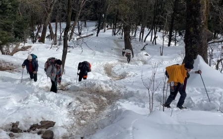
From Ghandruk, the trail climbs and dips through forests and small villages. Youll cross bridges and climb stone steps. After 56 hours, youll reach Chhomrong, a village sitting at 2,170 meters.
Day 2: Chhomrong to Bamboo
The next day, you descend to the Chhomrong Khola (river) and then climb steep steps to Sinuwa. From there, its a peaceful walk through the forest to Bamboo, your stop for the night.
Day 3: Bamboo to Deurali
Todays trail is a mix of forests and rivers. Youll pass through Dovan and Himalaya, stopping at Deurali around 3,230 meters. The trees thin out as you go higher, and the air grows colder.
Day 4: Deurali to Annapurna Base Camp
This is the big day. Youll pass through Machapuchare Base Camp (MBC) first, at 3,700 meters. Then, you climb gently toward Annapurna Base Camp (ABC) at 4,130 meters. The view is unlike anything youve ever seenhuge snowy peaks in all directions.
Looking at the map, youll see how the trail winds through valleys and climbs up steadily. Its not too steep, but the altitude makes it slow. Take your time. Breathe. Enjoy.
A Map That Brings You Closer
One moment on the trail still stays with me. It was the morning we left MBC. A soft snow had fallen overnight, and the whole trail looked like it was covered in sugar. I looked down at my map and traced the last section with my finger.
I realized how far I had come. Ghandruk felt like a dream. I was now walking at the foot of the tenth highest mountain in the world. The Annapurna Base Camp via Ghandruk map was no longer just paperit was my story.
Coming Back Down
After reaching ABC, most trekkers follow the same path back. Some may take a slightly different route through Jhinu Danda, known for its natural hot springs. Soaking tired legs in warm water, surrounded by forestits the perfect ending.
Back on the map, this route creates a small loop. It shows how even your way back can offer new places and fresh memories.
Why the Map Matters
Many trekkers today use phones and GPS. But carrying a printed Annapurna Base Camp via Ghandruk map is still smartand special. Heres why:
-
It works even when there's no signal
-
It helps you track your progress
-
It teaches you about local villages and landmarks
-
It builds a deeper connection with the trail
When I sat at teahouses each night, I would open my map and talk to other trekkers. Where are you going next? How far is Deurali? The map brought us together.
Final Thoughts: A Path Worth Taking
The trek to Annapurna Base Camp is not just a walk through the mountains. Its a journey of the heart. And the Annapurna Base Camp via Ghandruk map is your guide. Each village, each turn, each ridgeit all matters.
Youll sweat. Youll smile. Some days will feel long. But when you stand at the base of Annapurna, surrounded by quiet snow and the sound of the wind, youll understand why so many people fall in love with this trek.
And later, when you look at the map again, your heart will smile. Because now, that path belongs to you.
So, next time you see a trekking map, dont just glance at it. Study it. Carry it. Let it lead you on your own Himalayan adventureone step, one village, one mountain at a time.